People and Nature: Friends for Life

by Amy Berkov

Those of us who advocate for biodiversity in the East River Parks are not promoting nature over people. We believe from our hearts that people are part of biodiversity and that biodiversity provides many wonderful benefits for people. 

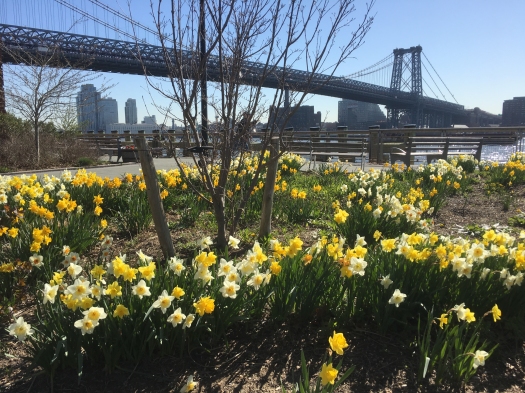
Trees extract carbon from the atmosphere and store it in wood; this is important because the carbon locked up in long-lasting wood no longer contributes to the greenhouse effect and global warming. Engineers are exploring methods to capture and store atmospheric carbon, but plants—and the soils in which they grow—still represent the most efficient technology! Trees also provide shade that lowers summer temperatures, and intercept pollutants. 

Sustained exposure to open space provides well-documented benefits to both mental and physical health—especially for children. As an educator, I believe that nature study improves observational skills, increases attention spans, and promotes critical thinking. These are all important to the future success of our urban students, who get much of their exposure to nature in NYC parks.

I do not know of any precedent for a city to completely destroy a large, bio-diverse park—used on a daily basis by diverse neighborhood residents. Before making dramatic changes in the landscape, the city undertakes a process called the ULURP (Universal Land Use Review Procedure) and prepares an EIS (Environmental Impact Statement). These reviews include at public hearings that give community residents a chance to weigh in on land use decisions.  For the benefit of both people and biodiversity, the city must take steps before approving the ULURP.  I believe that, before proceeding with this unparalleled destruction, the city must take the following actions: 

1) Bring in outside experts in coastal science to evaluate the city’s “preferred plan” to demolish the entire park.

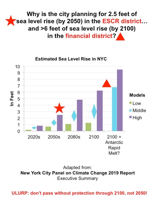
2) Incorporate projections for sea level rise by 2100, not the 2050s (the city is currently planning for > 6 feet of sea level rise, by 2100, in the financial district, but for only 2.5 feet of sea level rise, by the 2050s, along the East River from Montgomery to 25th Street).

estimated sea level rise

3) Revisit the idea of decking over the FDR (which might actually provide flood protection through 2100).

4) Agree to phased construction (not just phased re-opening); keep sections of the park open as other parts are under construction. 

If the city is permitted to execute their “preferred alternative” without modifications, they will close, demolish, and bury all 57 acres of park for a minimum of three years. Children, seniors, those with fewer resources and the plants and animals in the East river Parks will all be the biggest losers. 

Amy Berkov, a member of the Biology Faculty at the City College of New York, uses NYC Parks as outdoors laboratories to teach NYC students about local plants, insects, and their interactions.

“I Love This Park. I Grew Up in This Park”

Harriet Hirshorn interviewed some 50 people in East River Park in recent weeks. Most of them do not know that the park is going to be closed, bulldozed and covered with eight feet of dirt for flood protection starting next March.

Daffodils bloom in East River Park
Photo by Harriet Hirshorn

The video Harriet made shows how people use the park in all weather. Their quotes toward the end shows how alarmed and heartbroken park-goers are when she tells them about the city’s current plan. While the community understands the need for flood protection, many question whether the total destruction of the East River Park is the best plan.

The city is claiming that the neighborhood supports the East Side Coastal Resiliency Plan. That is not true. Most of the neighborhood doesn’t know about it. And when they find out, they oppose the drastic, unsupportable measures the city is determined to take.

We need a better plan!

“We Have a Lot of Questions”

Hear an interview with East River Alliance’s Naomi Schiller about the East Side Coastal Resiliency plan for flood control. She covers the range of our issues including these points:

Naomi Schiller

“Brooklyn Heights, a very wealthy neighborhood, was able–with pressure on public officials–to convene experts to rethink the BQE design.”

“So we are also asking for an independent panel…Does this plan meet the demands of the most recent climate science?.”

“We’re really concerned that equity has been pushed to the side, and this fast-tracked plan has been forced down our throats.

“We’re in a difficult spot. We want flood protection.”

“One of the most popular ideas several years ago was to place decking over the FDR…and to use part of that decking and berms to create coastal flood protection, which would have the possibility of reducing emissions in the community.”

And there are many more cogent points in this six-minute interview on WBAI. You can play the piece below:

Naomi Schiller on WBAI, April 17, 2019.

The Rivers Beneath the Streets

I am haunted by the underground rivers I see in historical maps of Manhattan.

I’m especially drawn to the mythic maze of subterranean streams under the East Village. These are left off the City’s public visualizations of the East Side Coastal Resiliency project (ESCR) project that is meant to protect our community from flooding. This is a potentially disastrous oversight that will affect my neighborhood as the sea level rises and climate change delivers increasingly intense storms.

Responding to my questions at public meetings, the Department of Environmental Protection says these subterranean streams are not under their jurisdiction, and they don’t know where they are. Why doesn’t the City have a Deputy Mayor for Infrastructure so agencies, adjacent projects and geography can be coordinated?

Look at some of the maps I’ve collected as background and inspiration for my work over the last 25 years. I map sustainable living resources including community gardens, greenmarkets, bicycling and solar sites. Since 2001, I’ve often included Manhattan’s historic shoreline to highlight how humans have impacted this “small island nation” and to foreshadow changes to come.

Townsend MacCoun’s map of Manhattan “at the time of its discovery” includes Native American villages (in red) and topography from 1609 with water-courses, marshes and shore line, overlaid with the 1867 street grid and harbor. Full of surprises, it was made for underpinning engineers, and still provides crucial knowledge for erecting new buildings and infrastructure.

In this map, the East Village looked especially vulnerable, with subterranean rivers and tidal salt marshes extending nearly to 1st Avenue. The book “The Archaeology of Home” tells how the land was extended and filled in, and how docks and shipyards soon ringed the shore. Even today, people in the community know that willow trees are indicators that these ancient waterways still flow. This year, test bores for rain gardens are being made in the same area for the Gardens Rising project, and there are reports on progress mapping the underground. Can’t these shed light for developing the ESCR, too?

Check out the Viele Map, dated 1865. Use the link to see a zoomable version of the map with amazing details of the land under and around the 58 acres of today’s East River Park. The orange is landfill and piers, with the green being the extent of the original shoreline. Land and water continually transform one another. Climate change is accelerating that evolution. No one really knows what’s coming, or when. It’s clear though, that these maps provide information critical to the planning of the ESCR.  

The Viele Map is properly known as the Sanitary & Topographical Map of the City and Island of New York. Use the slider at bottom center to zoom in and lay bare geographical vulnerabilities.

As a 30 year resident and as an individual active with the East River Alliance, I’m also sharing an example from my professional work with Green Map System. This post-Sandy view is the Adapting to Change, Lower East Ride edition. Produced in Spanish, Chinese and English in 2013, this small map promotes bicycling as an everyday climate change countermeasure. It includes both the super storm’s high water mark and the original shoreline, as well as the combined sewer outfalls in East River Park, the then new bike share stations, bike lane network, etc.

The next map I make will include the subterranean streams that still run under the community. As major changes to the geography are being prepared, I ask the City, will your ESCR plans include them, as well?

– Wendy Brawer


Thanks Mr. Mayor

On the Brian Lehrer radio call-in show on WNYC recently, Mayor Bill de Blasio supported phased closing of East River Park during the construction of the East Side Coastal Resiliency flood protection project. This is a change from the plan that would have closed the entire park for 3 1/2 years. This phased closing is one of the things we’ve been asking for!

Here’s from a transcript of the mayor’s encouraging remarks:

“… the idea is to have the park redone in segments so that [there] will be pieces of the park available to the community at all times and once one segment is done then another segment is addressed. So it’s – we’re very sensitive to the fact that people need their park space. “

The remark was in answer to a caller, Billie, who asked about what she called an “enormously risky, expensive plan…with a huge risk of failure, of incompletion…”

The mayor acknowledged there might be reason for cynicism, but said, “This has been a very carefully assessed project.” While he said, reassuringly, “It is being discussed with the community,” it’s clear we don’t have much time: “We have to get going. The resiliency issue is one of urgency, but I do want you to know none of this has been done lightly and I think when you see more the facts, you’ll be more comfortable that the East Side approach is going to work.”

If it is going to work for our community, we must continue to persuade the city that our alternatives will be better. We know from the mayor’s statement about phased closing, that he is listening. Now let’s keep pushing on protecting our community from toxic dust and other hazards, and insist on meaningful mitigation of the enormous adverse impacts of clear-cutting and bulldozing over 70 acres of public green space.

To hear to the show with Billie’s question and the mayor’s complete answer, follow the WNYC link.


Congestion Pricing and East River Park: Is This Why We Have to Close the Park Instead of Closing a Lane of the FDR?

From the earliest days of flood protection planning for the Lower East Side, decking over the FDR was a popular idea. It was a win-win-win: effective flood protection, less pollution, more and better recreation space. 

The city said it was too expensive.

Now that the ESCR budget has doubled to $1.45 billion, we have been asking, Why not reconsider decking over? 

One concern, we are told, is that it will take too long, and effective flood protection is an urgent issue. We contend that deployable walls, like the ones planned for Battery Park and the financial district, could ensure short-term safety and buy us time to slow down this frantic “preferred alternative plan.” But more on that in another post.


This week we learned that congestion pricing below 60th Street in Manhattan is coming soon. There’s just one catch: the FDR Drive will be exempt. 

“New technology can identify vehicles on any roadway and automatically charge them, so the task force was able to draw a narrower — and perhaps more politically palatable — cordon limited to the most crowded streets. In turn, that means drivers can enter Midtown and Lower Manhattan by two bridges without paying as long as they go directly to the F.D.R. Drive along the East River and then continue on it until they are out of the congestion zone,” wrote the New York Times on January 18, 2019.  


In other words, slowing traffic on the FDR for deck-over work — or closing a lane to allow flood protection to be focused at the back of East River Park — could threaten this “politically palatable” exemption from congestion pricing. If the FDR is not wide-open to traffic, it will be harder to placate drivers looking for a way around the additional charges.

It’s clear that the exemption will only increase traffic on the FDR — and increase air pollution just when the city proposes to strip over 65 acres of neighboring parkland of all trees and ground cover!  Here’s what we’d like to see instead: A comparative study of a decked-over FDR (supported by a concrete structure to provide the required flood protection). Safer homes. More parkland. Less pollution. What’s not to love?