2012 Hurricane Sandy strikes New York City. Sandy leaves dozens dead. The storm’s more than nine feet of storm surge from the East River causes extensive damage in the Lower East Side.
2013 President Obama launches a national design competition, Rebuild by Design, to develop projects to prepare for future disasters. Urban planners, architects and community groups come together to develop a coastal protection plan, known as the BIG U, to reduce the risk of flooding caused by climate-change related storm surge and rising sea levels in Lower Manhattan.
2014 US Department of Housing and Urban Development (HUD) selects the BIG U as a winner of the competition. NYC and HUD allocate $335 million to build the first section of the BIG from Montgomery to East 25th streets, calling it the East Side Coastal Resiliency (ESCR) project.
2014 –2017 The Lower East Side community engages in extensive planning meetings with NYC agencies to redesign the waterfront parkland from Montgomery to East 25th streets. Community Boards 3 and 6 set up a task force, and together with local stakeholders, engage in more than a dozen community engagement sessions to provide comments and feedback on the design. During that time, the City committed additional $425 million to the first section, for a total of $760 million. The proposed design includes a bermed flood barrier on the western part of the park, along the FDR highway, and intends to use East River Park to absorb storm surge water.
2018 March: Community Board 3 commits to endorsing the design for the East Side Coastal Resiliency project plan if certain adjustments are made, including solar and wind lighting, and more education about resiliency and climate change.
October 2018: After four years of planning, the Mayor’s Office announces that they are scrapping the approved design for the section of the East River Coastal Resiliency project from Montgomery Street to 14th Street, to instead install a flood wall along the water’s edge. The new plan is to destroy the existing park and build a levee on 8-10 feet of landfill from around Grand Street to 14th Street. The cost for the project is $1.45 Billion. Construction is planned for spring 2020, completion by 2023, closing East River Park for the duration of construction.
–Timeline by Naomi Schiller
Plans as they were and are
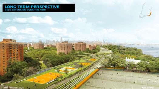
Rebuild by Design
A People’s Plan For the East River Waterfront
GOLES–Good Old Lower East Side–helped start LES Ready!, the longterm recovery group that formed in response to Sandy. Out of their grassroots organizing, the community was able to engage the Rebuild by Design process. Many other organizations contributed to the People’s Plan for the LES Waterfront even before Sandy. Check out this thoughtful and detailed report. It’s a history, survey, and recommendations.
https://caaav.org/publications/PeoplePlanFINAL.pdf
Formation of the East River Alliance
The East River Alliance is a coalition of volunteers from the Lower East Side to Kips Bay that formed organically when the city suddenly presented a plan in October 2018—without consulting anyone in our community—to close and demolish East River Park for at least three and a half years, and rebuild it eight feet higher for flood protection.
Our East River Park
A slide show of the wonders of East River Park in recent years and what we will lose.
https://patarnow.zenfolio.com/p313418955
Schedules Unkept, East River Park, a 21st Century History
a slide show of the painful 10-year rebuilding of the waterfront, a process that was promised to be two years by Pat Arnow:
https://patarnow.zenfolio.com/p249576553
More history to come.
If you would like to send information for this page or share comments and ideas, please email us: community@eastriveralliance.org
